![](/images/other/stat-length.png)
![Excursión A pie Saint-Antoine l'Abbaye - Saint Antoine l'Abbaye - Photo](https://media.geolcdn.com/t/1900/400/ext.pjpeg?maxdim=2&url=https%3A%2F%2Fstatic1.geolcdn.com%2Fsiteimages%2Fupload%2Ffiles%2F1545311037marcheuse_200dpi.jpg)
Saint Antoine l'Abbaye
JacouBrijou
Usuario
![Longitud](/images/other/stat-length.png)
Longitud
21 km
![Altitud máxima](https://static1.geolcdn.com/siteimages/upload/files/1508320355ic_sort_altitude_max_24dp.png)
Altitud máxima
642 m
![Desnivel positivo](https://static1.geolcdn.com/siteimages/upload/files/1508320355ic_sort_den_pos_24dp.png)
Desnivel positivo
533 m
![Km-Effort](/images/other/stat-length.png)
Km-Effort
28 km
![Altitud mínima](https://static1.geolcdn.com/siteimages/upload/files/1508320355ic_sort_altitude_min_24dp.png)
Altitud mínima
357 m
![Desnivel negativo](https://static1.geolcdn.com/siteimages/upload/files/1508320355ic_sort_den_neg_24dp.png)
Desnivel negativo
534 m
![Boucle](https://static1.geolcdn.com/siteimages/upload/files/16400158638029165_repeat_loop_refresh_sync_direction_icon.png)
Boucle
Sí
Fecha de creación :
2022-10-25 20:30:29.541
Última modificación :
2022-10-25 21:22:20.133
![A pie](https://static1.geolcdn.com/sitytour/trail-icons/100.png)
6h22
Dificultad : Medio
![Escanee este código QR para abrir la excursión en la aplicación SityTrail](https://capi.geolives.com/qq0zvz2zws4bq2lad0pu/sitytour/trails/3435590/qr.png?size=200)
Aplicación GPS de excursión GRATIS
A propósito
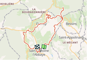
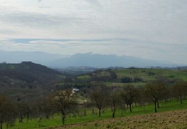
Ruta A pie de 21 km a descubrir en Auvergne-Rhône-Alpes, Isère, Saint-Antoine l'Abbaye. Esta ruta ha sido propuesta por JacouBrijou.
Descripción
Randonnée au départ de Saint Antoine l'Abbaye.
le tracé rejoint l'ancienne voie du TRAM Lyon - St Marcellin.
Au lieu "Chapelle de Rodon" possibilité d'effectuer un A/R pour aller admirer l'abbaye ND de Chambaran.
Localización
País:
France
Región :
Auvergne-Rhône-Alpes
Departamento/provincia :
Isère
Municipio :
Saint-Antoine l'Abbaye
Localidad:
Saint-Antoine-l'Abbaye
Salida:(Dec)
Salida:(UTM)
674392 ; 5004730 (31T) N.
Comentarios
Excursiones cerca
![Excursión Bici de montaña Chatte - De Chatte à St Antoine en passant par Chevrière - Photo](https://media.geolcdn.com/t/375/260/ext.jpg?maxdim=2&url=https%3A%2F%2Fstatic1.geolcdn.com%2Fsiteimages%2Fupload%2Ffiles%2F1524743154velo.jpg)
![Bici de montaña Bici de montaña](https://static1.geolcdn.com/sitytour/trail-icons/202.png)
De Chatte à St Antoine en passant par Chevrière
Bici de montaña
Muy difícil
(1)
Chatte,
Auvergne-Rhône-Alpes,
Isère,
France
![](/images/other/stat-length.png)
44 km | 60 km-effort
3h 53min
![](https://static1.geolcdn.com/siteimages/upload/files/16400158638029165_repeat_loop_refresh_sync_direction_icon.png)
Sí
![Excursión Senderismo Saint-Antoine l'Abbaye - saint Antoine l abbaye - Photo](https://media.geolcdn.com/t/375/260/ext.jpg?maxdim=2&url=https%3A%2F%2Fstatic1.geolcdn.com%2Fsiteimages%2Fupload%2Ffiles%2F1553511878bg_sport_marche.png)
![Senderismo Senderismo](https://static1.geolcdn.com/sitytour/trail-icons/101.png)
saint Antoine l abbaye
Senderismo
Muy fácil
(1)
Saint-Antoine l'Abbaye,
Auvergne-Rhône-Alpes,
Isère,
France
![](/images/other/stat-length.png)
6,9 km | 9,3 km-effort
1h 52min
![](https://static1.geolcdn.com/siteimages/upload/files/16400158638029165_repeat_loop_refresh_sync_direction_icon.png)
Sí
![Excursión Senderismo Roybon - Dionay - Photo](https://media.geolcdn.com/t/375/260/ext.jpg?maxdim=2&url=https%3A%2F%2Fmedia.geolcdn.com%2Ff%2F8b746741-3496-4ce2-91f1-c91c1779e6d7.jpg)
![Senderismo Senderismo](https://static1.geolcdn.com/sitytour/trail-icons/101.png)
Dionay
Senderismo
Difícil
Roybon,
Auvergne-Rhône-Alpes,
Isère,
France
![](/images/other/stat-length.png)
9,6 km | 12,1 km-effort
1h 54min
![](https://static1.geolcdn.com/siteimages/upload/files/16400158638029165_repeat_loop_refresh_sync_direction_icon.png)
Sí
![Excursión Bici de montaña Chatte - chemin du tram part1 - Photo](https://media.geolcdn.com/t/375/260/ext.jpg?maxdim=2&url=https%3A%2F%2Fmedia.geolcdn.com%2Ff%2F4b96f262-5eb3-483c-bd05-b1126f93c437.jpg)
![Bici de montaña Bici de montaña](https://static1.geolcdn.com/sitytour/trail-icons/202.png)
chemin du tram part1
Bici de montaña
Muy fácil
Chatte,
Auvergne-Rhône-Alpes,
Isère,
France
![](/images/other/stat-length.png)
11,4 km | 14,1 km-effort
1h 16min
![](https://static1.geolcdn.com/siteimages/upload/files/16400158638029165_repeat_loop_refresh_sync_direction_icon.png)
Sí
![Excursión Senderismo Saint-Antoine l'Abbaye - st. Antoine l'Abbaye - Photo](https://media.geolcdn.com/t/375/260/ext.jpg?maxdim=2&url=https%3A%2F%2Fservices.sitytrail.com%2FGeolivesWS%2FDownloadMedia.ashx%3FTrailID%3D673116%26Media%3Dfix__20161215092710.jpg)
![Senderismo Senderismo](https://static1.geolcdn.com/sitytour/trail-icons/101.png)
st. Antoine l'Abbaye
Senderismo
Fácil
Saint-Antoine l'Abbaye,
Auvergne-Rhône-Alpes,
Isère,
France
![](/images/other/stat-length.png)
21 km | 28 km-effort
5h 36min
![](https://static1.geolcdn.com/siteimages/upload/files/16400158638029165_repeat_loop_refresh_sync_direction_icon.png)
Sí
![Excursión Senderismo Saint-Antoine l'Abbaye - cap'r à Dionay - Photo](https://media.geolcdn.com/t/375/260/ext.jpg?maxdim=2&url=https%3A%2F%2Fservices.sitytrail.com%2FGeolivesWS%2FDownloadMedia.ashx%3FTrailID%3D404513%26Media%3Dfix__20150328102558.jpg)
![Senderismo Senderismo](https://static1.geolcdn.com/sitytour/trail-icons/101.png)
cap'r à Dionay
Senderismo
Fácil
Saint-Antoine l'Abbaye,
Auvergne-Rhône-Alpes,
Isère,
France
![](/images/other/stat-length.png)
8,7 km | 11,4 km-effort
1h 16min
![](https://static1.geolcdn.com/siteimages/upload/files/16400158638029165_repeat_loop_refresh_sync_direction_icon.png)
Sí
![Excursión Senderismo Saint-Antoine l'Abbaye - Lac Chapaize / St Antoine - Photo](https://media.geolcdn.com/t/375/260/ext.jpg?maxdim=2&url=https%3A%2F%2Fstatic1.geolcdn.com%2Fsiteimages%2Fupload%2Ffiles%2F1553511878bg_sport_marche.png)
![Senderismo Senderismo](https://static1.geolcdn.com/sitytour/trail-icons/101.png)
Lac Chapaize / St Antoine
Senderismo
Medio
Saint-Antoine l'Abbaye,
Auvergne-Rhône-Alpes,
Isère,
France
![](/images/other/stat-length.png)
7,1 km | 9,4 km-effort
2h 7min
![](https://static1.geolcdn.com/siteimages/upload/files/16400158638029165_repeat_loop_refresh_sync_direction_icon.png)
Sí
![Excursión Senderismo Saint-Antoine l'Abbaye - Bourgeonnière départ Le Mouchet - Photo](https://media.geolcdn.com/t/375/260/ext.jpg?maxdim=2&url=https%3A%2F%2Fstatic1.geolcdn.com%2Fsiteimages%2Fupload%2Ffiles%2F1553511878bg_sport_marche.png)
![Senderismo Senderismo](https://static1.geolcdn.com/sitytour/trail-icons/101.png)
Bourgeonnière départ Le Mouchet
Senderismo
Difícil
Saint-Antoine l'Abbaye,
Auvergne-Rhône-Alpes,
Isère,
France
![](/images/other/stat-length.png)
11,4 km | 14,8 km-effort
4h 33min
![](https://static1.geolcdn.com/siteimages/upload/files/16400158638029165_repeat_loop_refresh_sync_direction_icon.png)
Sí
![Excursión Paseo ecuestre Saint-Antoine l'Abbaye - J4_boucle_St Antoine l'Abbaye foret de Thivolet 17/4 - Photo](https://media.geolcdn.com/t/375/260/ext.jpg?maxdim=2&url=https%3A%2F%2Fstatic1.geolcdn.com%2Fsiteimages%2Fupload%2Ffiles%2F1524743154cheval.jpg)
![Paseo ecuestre Paseo ecuestre](https://static1.geolcdn.com/sitytour/trail-icons/301.png)
J4_boucle_St Antoine l'Abbaye foret de Thivolet 17/4
Paseo ecuestre
Difícil
Saint-Antoine l'Abbaye,
Auvergne-Rhône-Alpes,
Isère,
France
![](/images/other/stat-length.png)
26 km | 34 km-effort
4h 31min
![](https://static1.geolcdn.com/siteimages/upload/files/16400158638029165_repeat_loop_refresh_sync_direction_icon.png)
Sí